Marine action tracker
Action 1 – Research

Below are current actions in addition to those reported in the Ocean Watch - 2020 Edition
+ 1.1 Conduct baseline studies and ongoing monitoring of key indicator species and habitats to guide conservation actions.
- Biomass of Plankton Surveys will be conducted January 2021-October 2021. The main objectives of this project is to research; 1) the seasonal distribution of phytoplankton, 2) the seasonal distribution of zooplankton, 3) factors influencing phytoplankton production, 4) impacts of natural and man-induced stressors on phytoplankton and 5) changes between this study and the Stockner et al. (1972) study. This is a partnership between Pacific Salmon Foundation and the Marine Reference Guide. Read the abstract here. In January, 2023, the results of the monitoring were published by the Marine Stewardship Initiative, found here.
- The distribution of eelgrass (Zostera marina) was surveyed along the Sounds mainland shoreline, from Horseshoe Bay to Squamish to Gibsons by the Marine Reference Guide team. This data were collected during a survey in September 2019 and is ongoing. This involved mapping the full extent of eelgrass beds to enable identifying changes in eelgrass distribution and health that have occurred between 2004-2019. Read more here
- The Gambier Island Conservancy conducted a preliminary sensitive species assessment on Whispering Creek on Gambier Island.
- From February to April, Pacific herring (Squamish name: Slhawt’, Latin name: Clupea pallasii) return from the open ocean to Howe Sound/Átl’ka7tsem to spawn. In the winter and spring of 2021 and 2022 the Marine Stewardship Initiative, Squamish Nation, and Cultural Journeys continued the work of local citizen scientist (John Buchanan) to collect data on herring spawn in Howe Sound/Átl’ka7tsem. With two people in a boat and a swimmer, they looked for new spawning sites, returned to old spawning sites, monitored the egg health and development, and took egg counts. In 2022, there has been a team of volunteers going out to survey 9 nearshore locations in the Squamish area. A number of sites have been positive for herring spawn. Read more here I January 2023, the results of the surveys were published in a report by the Marine Stewardship Initiative and can be found here.
- In Spring 2021, Ocean Wise published the 2021 lingcod egg mass survey (LEMS) report.
- The Town of Gibsons has implemented the following modeling and monitoring initiatives to assess potential impacts to natural assets in the region from climate change: Creek Monitoring Stations: Staff and Streamkeepers members have continued taking flow measurements at each of the three creeks (Chaster, Charman and Gibson) and have exported the data to Waterline Resources to develop a flow rating curve. This rating curve is being used for stormwater modelling in the Source to Sea project. Additionally, the Town is currently working with Swiftwater Consulting to install additional monitoring stations in Chaster and Gibson Creek in 2022.
- The Town of Gibsons is in Phase 2 of the Source to Sea project September 2022. The project team completed a risk identification exercise and determined that the natural asset types that faced the highest number of risks were creeks (7 high risks) and riparian areas (6 high risks), followed by foreshore (4 high risks) and the urban forest (4 high risks). Thirteen risks were considered - Read more here. The project team will wrap up Phase 2 which will model the future scenarios as listed above and assess the effects to the identified natural assets. Phase 3 will see the analysis of the data and the creation of technical reports: Co-benefits Valuation, Watershed Stormwater Modelling Component, Risk Management and Simulation Modelling of Integrated Natural Asset Management.
- The Glass Sponge Research Initiative have been surveying Howe Sound sponge reefs in 2022 documenting damage to the Halkett Bay reef. Data has been collected and more information is pending.
- Under the coordination of the Marine Stewardship Initiative, herring surveys have been initiated for the 2023 season, recruiting a record number of volunteers and employing Squamish Nation ACE Technicians. This runs February through to April 2023.
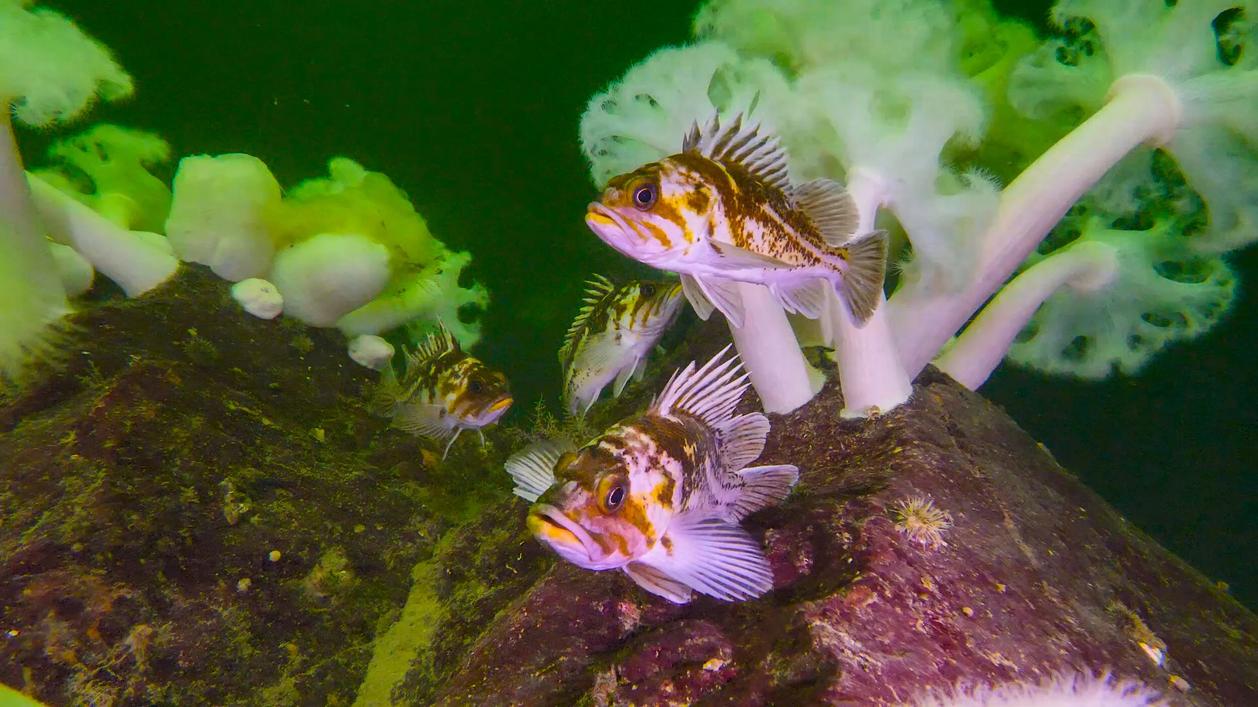
ADDED June 2023 * Fall 2022, Marine Life Sanctuaries Society (MLSS) in partnership with Howe Sound Biosphere Region Initiative Society relaunch the Howe Sound Rockfish monitoring project. MLSS receives funding from Fisheries and Oceans Canada in support of the project that involves identification of monitoring sites, volunteer diver training, collection of data. Marine Stewardship Initiative is supporting the data collection and storage.
+ 1.2 Conduct ongoing monitoring of the impacts of climate change and ocean acidification to support adaptation and action.
- The Sunshine Coast Streamkeepers Association began monitoring 4 creeks, 2 in Howe Sound starting in September 2020 for Air and Temperature. With support from Fisheries and Oceans Canada the project provides a better picture of how climate change is affecting the natural habitat of wild salmon.
+ 1.3 Address key knowledge gaps that develop as knowledge increases.
- From the Pacific Science Enterprise Centre: Howe Sound research: Log handling areas, also known as log dumps, are foreshore locations where harvested timber enters the water for sorting, booming and transport. Dislodged bark and whole logs can sink to smother the sea floor, interrupting natural aerobic processes and altering biota; recovery can be very slow. Sonar technologies may allow the delineatation of the area and the depositional thickness of wood debris. Results inform best management practices for recovery and remediation, and improve site selection regulations. Principal investigator: Herb Herunter
- In conjunction with the Coastal Resilience project, Town of Gibsons staff are developing the “Source to Sea Project” (S2S) with Municipal Natural Assets Initiative to consider natural assets within the extent of the Gibsons Aquifer watershed. Goals of the project include: • establishing a baseline inventory of the natural assets that support water services; • providing a condition assessment of the identified areas; • understanding of the level of service of the identified natural assets; and • recommending best management practices of the natural assets identified. Read more here.
- The Town of Gibsons has completed a "Managing Natural Assets to Coastal Resilience" project, to understand the value of our natural coastal assets (eelgrass beds, beaches, and rocky shorelines, etc.) and how these assets could mitigate effects from floods, storm surges, and coastal erosion. Project results will inform the Town’s restoration work over the coming years, and the project team hopes to have created a replicable model for other local governments to follow. The full report can be found on the Town’s website.
- Through a pilot project with MNAI, staff was engaged in developing a new guidance document, “How to Develop Levels of Service for Natural Assets and Ecosystem Services”. The document aims to support local governments to better integrate natural asset management into asset management policies, plans, and programs. MNAI recognized the importance for local governments (LGs) to develop an understanding of the services natural assets are providing or can provide to the community. This understanding enables LGs to define a level of service they will commit to sustaining over time, whether that is through conservation, adaptive management, or other programs that might require collaboration and partnerships with private landowners or other government jurisdictions.
- Chaster Creek Watershed study will look at areas within the Town in the Chaster Creek Watershed to determine how much flow from the Town is draining to Chaster Creek and to explore options and responsibilities for reducing flows to the creek. Consultation and collaboration with the SCRD and the Ministry of Transportation and Infrastructure (MoTI) will be part of this work.
- Douglas College is conducting research on water quality in Howe Sound, particularly with regard to maintaining the health of glass sea sponge reefs, and predicting likely locations of these reefs. The impacts of climate change on water quality and therefore the maintenance of these reefsis also being addressed. The Use of Water Quality Analysis to Predict and Protect Glass Sea Sponge Reefs in Howe Sound. Research began Winter 2022 with a student conducting an Environmental Science project on silicate analysis of oceanwater in Howe Sound, particularly surrounding Bowen island (September Morn and Dorman Point) For more information conatct Dr. Brenda Addison-Jones Addison-Jones, Douglas College Chemistry Department.
**Added June 2023: *Howe Sound Biosphere Region Initiative Society initiated a study to review data on fish bearing streams in Howe Sound to identify data gaps and restoration opportunities. Report is available here.
+ 1.4 Improve availability and sharing of data.
- The Átl’ḵa7tsem/Howe Sound Marine Stewardship Initiative has been conducting yearly training workshops on the Marine Reference Guide with local municipalities and the Squamish Nation. This was used as a way for GIS departments around the Sound to increase their understanding of the Guide and provide any updates for the MRG. The Átl’ḵa7tsem/Howe Sound Marine Reference Guide contains hundreds of spatial and non-spatial data layers that describe Átl’ka7tsem/Howe Sound’s aquatic ecology, biophysical environment, administrative boundaries, and human uses.
+ 1.5 Increase participation and engagement of First Nations knowledge holders in Western science.
- The Marine Stewardship Initiative in partnership with UBC conducted 30 interviews with Squamish Nation members on what they value in the Átl'ka7tsem / Howe Sound. The information received forms part of the research report about ecological, social, cultural and economic values associated with Átl'ka7tsem / Howe Sound.
- Squamish Nation members have been taking part in surveying Slhwat/herring in Átl'ka7tsem / Howe Sound through a project led by the Marine Stewardship Initiative.